SOFTWARE - [Remote GPS Debugger Tool]
GPS Debugger Tool is a very specific piece of software. I wrote it as a tool to debug and develop GPS-based Android-applications. The GPS Debugger Tool show a Google Map that can be controlled by UDP-packets.
I built this tool during the development of a new Android-app that creates approximately-alerts to specific GPS coordinates. I needed it to verify if the algorithms were working well. The idea is this: I temporarily added some code to the app, so it transmitted the current GPS coordinates as UDP-datagrams. Each time the GPS Debugger tool receives a coordinate, it immediately displays it on the map.
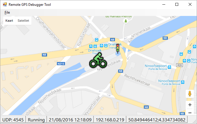
The tool acts like a webbrowser that is displaying a local HTML-page with a Google-Maps. You can choose your own HTML-page so you can completely customize the map.
The tool passes information to the Google Maps by calling a specified JavaScript function with a few parameters. You just need to make sure this JavaScript function exists. The program supports two modes:
The system is quite flexible and doesn't necessarily need to show a Google Map. You can create a HTML-page that only outputs text messages.
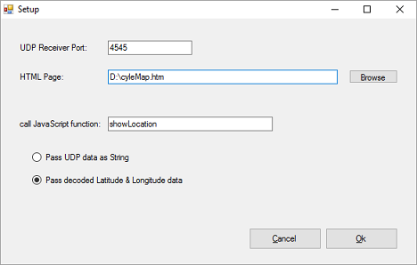
This tool is using UDP datagrams to receive data. They can be transmitted by all kind of programming languages, like Visual Basic and Java. The zipped download contains some basic code examples on how to send datagrams.
You can let the program decode the datagrams, but then the data must be in the following format: latitude;longitude (numbers separated by a semicolon). Or you can choose to transfer the unprocessed datagram to the HTML page, and let JavaScript do the decoding.
Here you can download the full setup application for the UDP-debugger. The download is a ZIP that also contains some examples.
Copyright ©1998-2022 Vanderhaegen Bart - last modified: August 21, 2016
