ANDROID - [VisuSpeed]
VisuSpeed is a very small app I wanted to build for a long time. It a tool to measure the speed of moving vehicles. Not by means of any electronic sensors, but visually. For this you first need to define two watchpoints you will be observing visually. To measure the average speed you need to press a button when the watched vehicle passes one of the watchpoints.
This app could be used to measure the speed of cars in your street. It often happen people are complaining about speeding cars in their street during rush hour. Complaints aren't taken seriously because authorities says the complainers are over-estimating the speed. With VisuSpeed you can test and document the true average speed.
Disclaimer: this tool can be quite accurate but it must be used properly!
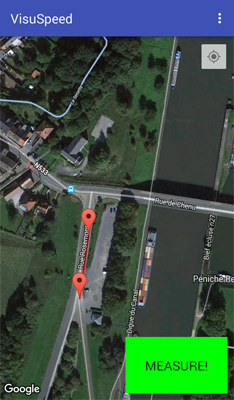
When you open the app it starts displaying a Google Map. First you need to define two waypoints A & B. The waypoints can be added by pressing the map for a few seconds. You can fine-tune the positions by dragging them to the correct location.
Next, you can proceed to the measurements by clicking the green button. The measuring screen has a big button you need to push when a moving vehicle passes each waypoint. The measured speed will appear on the screen immediately.
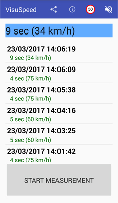
A list with results is displayed immediately. You can delete incorrect measurements by swiping the desired line to the right. You can also set a speed-limit by tapping the traffic-sign. Measurements that exceed this speed limit will be colored in red.
You can share/export the measurement data as a CSV file (Comma Separated Values). It can be opened in Excel or similar software.
The app can calculate the speed using the formula speed = distance/time. The distance is calculated from the GPS-coordinates of each waypoint. The time is the measured interval between two button presses.
The used distance is the shortest possible distance between the waypoints. This distance will also be displayed as a red line on the Google Map. This means you can only use the app on straight stretches of street. It is advised position the waypoints at locations that are easily identifiable visually, both on the Google-Maps and reality.
It is advised to perform measurements over longer distances (100 meter or more). This will lead to a better accuracy.
The app is not available on the Google Play store. You can download the APK file with this button, so you can install it manually to your smartphone.
The app is not yet finished completely but it is functional. It still need some important improvements like better handling of screen-rotation events.
Copyright ©1998-2022 Vanderhaegen Bart - last modified: March 23, 2017
